檔案:Srivijaya Empire.svg
跳至導覽
跳至搜尋


此 SVG 檔案的 PNG 預覽的大小:468 × 476 像素。 其他解析度:236 × 240 像素 | 472 × 480 像素 | 590 × 600 像素 | 755 × 768 像素 | 1,007 × 1,024 像素。
原始檔案 (SVG 檔案,表面大小:468 × 476 像素,檔案大小:336 KB)
摘要
| 描述 |
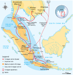
English: Maximum extent of Srivijaya Empire around 8th century. Expanding from Sumatra, Central Java, to Malay Peninsula. The red arrows show the series of Srivijayan expedition and conquest, in diplomatic alliances, military campaign, or naval raids. |
||
| 日期 | |||
| 來源 | Own work by uploader,redrawed from Munoz "Early Kingdoms of the Indonesian Archipelago and the Malay Peninsula" page 128 | ||
| 作者 | Gunawan Kartapranata | ||
| 授權許可 (重用此檔案) |
我,本作品的著作權持有者,決定用以下授權條款發佈本作品: 此檔案採用創用CC 姓名標示-相同方式分享 3.0 未在地化版本授權條款。
您可以選擇您需要的授權條款。 |
||
| 其他版本 |
[]
|


| This SVG file contains embedded text that can be translated into your language, using any capable SVG editor, text editor or the SVG Translate tool. For more information see: About translating SVG files. |
References
Resources used to create the map:
- Munoz, Paul Michel (2006年) 《 Early Kingdoms of the Indonesian Archipelago and the Malay Peninsula》、新加坡: Editions Didier Millet、pp. 128, 141 ISBN: 9814155675.
檔案歷史
點選日期/時間以檢視該時間的檔案版本。
| 日期/時間 | 縮圖 | 尺寸 | 使用者 | 備註 | |
|---|---|---|---|---|---|
| 目前 | 2024年9月20日 (五) 18:24 | | 468 × 476(336 KB) | Getsnoopy | Fixed some formatting issues. |
檔案用途
下列頁面有用到此檔案: